 |
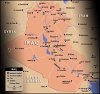
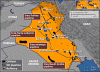
1. |
Iraq
Map of Iraq, its major cities and airports, primary roads, and rivers |
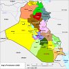 |
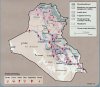
2. |
Iraq - Provinces
Map of Iraq's 18 provinces |
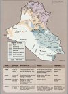 |
3. |
Iraq - Distribution of Ethnoreligious Groups and Major Tribes
Map of Iraqi ethnic, religious, and tribal groups |
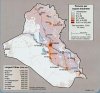 |
4. |
Iraq - Population Density
Map of Iraq's population per square kilometer and population of Iraq's largest cities |
 |
5. |
Iraq - Oil Fields
Map of Iraq's oil fields, pipelines, and refineries |
 |
6. |
Iraq - Land Use
Map of Iraq's use of land for food and agriculture |
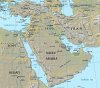 |
7. |
Middle East Relief
Map representing the geographic terrain of the Middle East |
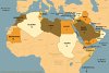 |
8. |
Arab League
Map of the 22 countries in the Arab League |
 Top 10 Pro & Con Arguments
